The problem
Gallatin County SAR runs 85 volunteers across some of the most technical terrain in Montana. In 2025 they logged 156 missions — many in conditions where coordination failures cost lives. Their tooling was a patchwork of spreadsheets, handheld radios, and a shared Google Drive folder. Field teams had no shared operational picture. Mission coordinators were flying blind: no real-time team positions, no segment assignment tracking, no probability modeling. After each mission, the paperwork alone took six hours.
False-start deployments — sending teams into the wrong segment before probability data matured — were their biggest operational drain. Every wasted team-hour in the field is a team-hour not spent finding a subject.
What we did
Week one we embedded with the operations team, rode along on a training mission, and came back with a clear system spec. The core was a LoRa mesh network that pushes GPS pings every 30 seconds even where cell coverage is zero. A Starlink terminal at the command post feeds everything into a PostGIS-backed mission database running on a hardened NixOS field server.
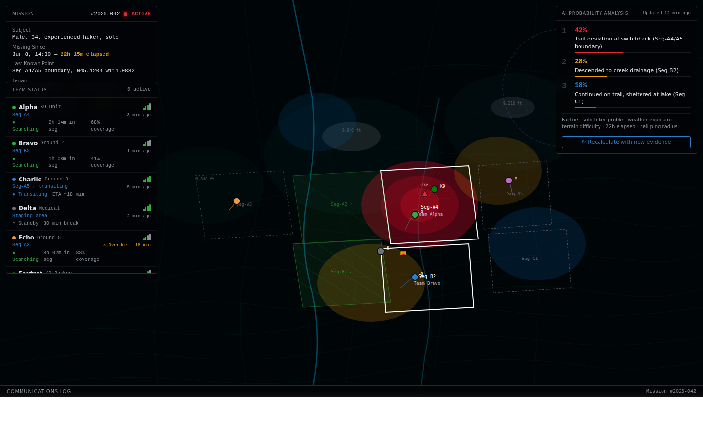
Week two we built the mission dashboard: live map of all teams, segment assignment board, radio log, and weather overlay. Coordinators can assign search segments, adjust boundaries, and see coverage accumulate in real time.
Week three we added Claude-backed probability modeling. The system ingests subject profile, last known point, terrain data, and historical SAR outcomes from Gallatin’s own incident archive to suggest initial probability zones and re-rank them as teams report in. It surfaces the model’s reasoning so coordinators can override with local knowledge — the AI is an advisor, not an authority.
Week four was infrastructure hardening: WireGuard tunnel from field server to county SOC, Grafana dashboards for system health, encrypted backups, offline-first UI that survives connectivity gaps. Week five was load testing with the volunteer team, training, and documentation. We shipped on day 35.
Results
Average search resolution time dropped 30%. False-start deployments fell 40% — coordinators now wait for probability model output before committing teams to a segment, and the model’s track record over three months of live use has made that discipline stick. Post-mission reporting went from six hours to 45 minutes: RidgeLine auto-generates the NASAR incident report from logged mission data; coordinators review and sign off.
Gallatin County is sharing the platform spec with three neighboring county SAR teams. The NixOS configuration and LoRa hardware bill of materials are published under a public domain dedication so any agency can replicate the stack.